Pilot Mountain

By Geoff Hardy

Posted on 8/12/2018 6:50 PM

We didn’t have ideal conditions for our trip up Pilot Mountain. We sheltered under a tree for 50 minutes while a thunder storm passed. We were blasted with snow and rain on the way to the summit. The summit was socked in the clouds so there were no views. Mount Brett was buried in dark clouds so we decided to postpone that peak for another day.

Despite all this, Pilot was one of my favourite scrambles. The 5km bike approach is reasonably straightforward and saves a lot of time – you barely need to pedal on the way out. The scrambling sections at the top were a whole lot of fun.

Descending behind the flake:

Our route:

Mosquito Mountain

By Geoff Hardy

Posted on 8/6/2018 8:48 PM

Mosquito Mountain was unusual in that the descent route was more interesting than the ascent. The route up a a reasonably straightforward easy scramble, with fantastic scenery of course. On the way down, I took Nugara’s suggestion to descend the south ridge to a turquoise lake. This ridge had the only real scrambling on the whole route and the lake was one of the coolest alpine lakes I have seen.

From the summit:

The descent ridge:

I can’t get enough of this lake:

The route went clockwise:

Bugaboos 2018

By Michael Shoemaker

Posted on 7/21/2018 6:31 AM


A Bugaboo Dream – 44 years in the making


I still remember the day, perhaps it was in the fall, at JR Smallwood Collegiate in Wabush, Labrador, 1974. I was in grade 4 and Ms. Young (my all time favourite teacher) was giving our Geography Lesson. Our textbook had a picture of … perhaps it was Bugaboo Spire. The name enthralled me … and the picture compelled me.


Last weekend (July 13-16, 2018) I hiked up to the Alpine Club of Canada’s Conrad Kain Hut in Bugaboo Provincial Park with the Calgary Mountaineer Scrambling Club. It was my 3rd time to the Hut in the last 10 years. The previous two times were day hikes.


Prior to the trip, I got myself a fancy new 35 litre mountaineering backpack and rented mountaineering boots and crampons from University of Calgary Outdoor Center.  (At MEC, I asked, “what makes a mountaineering backpack a mountaineering backpack?” They sit higher, the waist belt isn’t big and cumbersome to allow easy access to your harness, there is a place to put an ice axe and your crampons. Made sense … I bought one.)


On our first full day (Day #2) our focus was Pigeon Spire. I really knew nothing about it … but I did set it as an objective when signing up with CMSC … on request, a couple of friends had told me that I probably had the skills to do it.


We planned to leave the hut at 6am. About a 2.5 hour hike up ~1100 meters from the Hut over glacier and a very steep Col between Snow Patch Spire and Bugaboo Spire – crampons required, led us to the base of Pigeon Spire.


I was matched with Andrew and Al … Andrew was looking forward to increasing his skills at setting Anchors and placing “Trad Gear” along this 5.4 route. Al, a long time mountain guy with lots of experience … hadn’t been in the mountains for a couple of years …. and looked forward to “feeling it” again.


We started on our way.  I was shocked! This is 5.4!   Since about 1991 … I have done various climbing … and have managed to climb upto 5.10b. This was different. EXPOSURE.  A fall – could have you dead. However, why fall?! 5.4 – done with confidence, is pretty easy.


Not being confident, I was happy to be on a rope with Andrew and Al … taking our good ole time … pitch after pitch.  At some point, Al suggested we have a “Turn Around Time”. We agreed, that if at 2:30pm … we weren’t at the summit, we would turn around and be home for supper.


At one point, another CMSC member – Anna, and her group of 3 others … ripped past us – soloing the entire route. They were basically running up the spire – unroped. Shocked – again!  (I want that!!!)

Wow – to have the confidence … to scramble up this ridge – unroped.


At 3:30pm … we were at the top of the 2nd (3019 meters) of 3 summits to Pigeon Spire. We called it … and turned around. I was happy. We would be home before dark.


We exited of the Spire, climbing down the glacier to the hut. The snow was soft at this point, so we did not use our crampons. It was a nice run down hill.


Back at the Hut, at 8pm – completely exhausted physically and mentally, I immediately headed to my bunk … and slept 12 hours.


On Sunday, Day #3 … after a lazy morning in the hut, Andrew suggested we do a 5.7 – Lions Way on Central Spire. I asked, “What makes you think I have the skills?”  If he was game to lead, I was game to follow.


After some not so easy route finding, we were at the base of Central Spire and the beginning of Lions Way at 2pm. At 4:30 … we were on our 3rd pitch … and spent about an hour going up … what seemed like a 5.9 route. It was beyond our ability (we were off route).  We were happy to turn around and repel down, making it back to Conrad Kain Hut for Supper.


On reflection, I feel like I’ve been preparing for this trip since 1974!  I look forward to more scrambling including future trips to The Bugaboo’s – doing more routes, and finishing the routes we started.

Bryon Howard

Mt President Mountaineering Trip

By Lisa Lee-Johnson

Posted on 7/5/2018 4:19 PM

Seven of us went into the Little Yoho Valley to attempt a mountaineering trip up the Presidents (President and Vice-President) during the July long weekend. Despite that the weather wasn’t ideal, we all enjoyed the trip, and 5 of us made it to the summit of the President (but not VP).


Our group, consisting of myself (Lisa), Oscar, Jag, Curtis, Ildar, Jason and Pete walked in on the Friday up to the campsite in the Little Yoho Valley (near the Stanley Mitchel hut). Our packs were heavy as we were bringing an extra day’s food for a bonus day of Kane scrambles after the President’s ascent, plus lots of snow pickets due to a report of very icy snow on the summits from Paul who was in there a few days before us.


As it turned out, snow fell during the few days before our ascent, hence the snow was softer allowing us to solo the summit section without pitching using the pickets. (However I do recommend that climbers bring 2 to 3 pickets per rope team for Prez/VP. This may allow pitching if a party member isn’t confident with the summit ascent (or descent). Also, even in late-season when the summits are dry of snow, the shrund just before the col can be difficult to cross and may require protection to traverse safely.)

The last ½ km before the hut was difficult due to mountains of treefall brought down by late-spring avalanches. The easiest way through the deadfall was climbers left against the riverbank. On arrival in camp, Oscar and I went to scout up the first 30 min of the route, and the team went over our crevasse rescue technique before going to bed by 7pm to get some sleep before our early start.

On summit day we got up shortly after 2am and were walking by 3.15am, making us the first team on the mountain that day (and giving us the privilege of breaking trail all the way to the col for the benefit of the 2 guided parties and one other private group following us). The glacier travel was uneventful, if interesting and reasonably scenic until we walked up into the cloud layer as we reached the col between President and Vice-President. We had a fairly strong group (for a club trip) in terms of glacier experience, with Pete and I having extensive experience on the much more challenging glaciated terrain of New Zealand mountains, and Ildar having completed rather rigorous mountaineering training through his former mountaineering club in Russia. The bergschrund just below the col was well bridged and presented no difficulty to cross, unlike the last time I’d been up there in late season.

On the col we were overtaken by the three parties following us, as we debated whether to undertake the rather daunting looking President summit in the worsening weather. (Whiteout, and the summit was well plastered in snow.) The private party of three went ahead of us, which gave us a welcome break in the trail breaking. Two of our party decided to wait just above the col (one due to gear issues and one having had sufficient past experience with whiteout summits and not interested in a repeat), while the rest of us unroped to solo the summit section. We soloed because there were no crevasses from a short way above the col, and because climbing roped without runners creates unnecessary risk. (Guide’s studies have proven that a challenging ice axe self arrest is rarely successful when done by a roped team falling while tied together.)

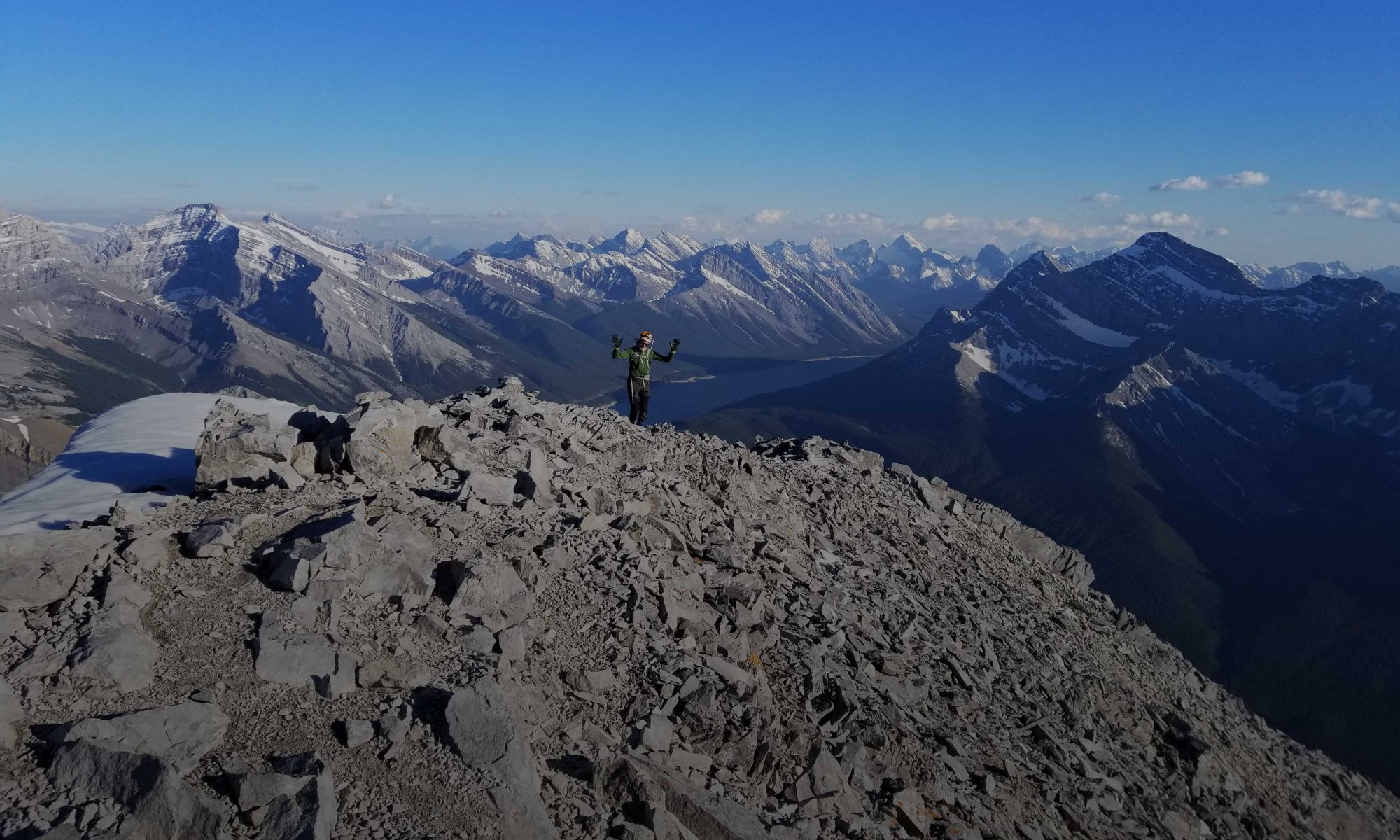
(Photo by Ildar, of the party in front of us)

For safety during this ascent, I was pleased that many of our party had joined our CSMC ice axe self arrest practice session a couple of weeks earlier. A slip on the summit section would have presented a risky and difficult self arrest, with the chances of surviving a fall considerably higher for someone who’d rehearsed the techniques recently. (Including the critical importance of raising the feet for a successful self arrest while wearing crampons.) That said, there were several sections where falling was a very bad idea. We took our time and watched out for each other, placing our ice axes up to the hilt (where possible) as a strong protection should the crampons slip. This summit climb was a lot more challenging than the previous time I’d climbed it as a moderate-grade rock scramble in late season.

(Photo by Ildar)

Nearing the summit we overtook the three other parties, and decided to continue to the real summit past the point where the guides too their clients just before the summit. Some debate occurred as to where the real summit was (in total whiteout), and we continued a short way down past the summit before we managed to convince our gps’s that we really had made it, reaching the summit around 9am. We took some pics and I InReached Tom from the summit to report our success, and then we headed down, taking our time as the descent proved considerably more intimidating to the less experienced members of the team, as descents always are.


Reaching the col, our two team members were ready to head down promptly, being very cold from waiting in the poor weather for our slow summit climb. One of our summit group clipped in to their rope of 3, and our second rope of 4 followed soon after. Nobody (including the guided parties) considered climbing VP in the poor weather and challenging snow conditions.


The glacial descent was fast and uneventful, except for an accidental detour off route through the cliff bands at the bottom of the valley, due to carelessly following one of the guided parties (it turned out the guide was teaching his client how to route find through bluffed out rock terrain.) We were exhausted but very happy with our success on arrival in camp around 1pm.


After a much-needed nap, Oscar, Pete and Jag decided to head out that evening. Idar, Curtis, Jason and I stayed another night, for an ascent of the first peak of Mt Kerr the following day. We stopped short of climbing the main Kerr summit as once again the weather packed in as we were approaching the summit. Curtis did a nice job of leading the group this day, with welcome assistance from Jason’s good route-finding and cairn-spotting skills on the descent. Kerr is graded as an easy Kane scramble, although I’d put it at the harder end of “easy” (even without some snow sections increasing the difficulty for us).

Arriving back at camp around lunchtime, we had a break and then walked out – getting home a day earlier than planned due to very poor weather forecast for the Monday.

A very fun, social, and successful mountaineering trip. Thanks to the whole team for the camaraderie and supporting in various ways to make this trip happen, for helping to carry the heavy gear (as I was rather unfit for such a challenging trip this early season!), as always to Tom for leading the CSMC as President and helping in many ways to make this trip possible, to Jag for renting us two large tents, and especially to Oscar who stepped in late to co-lead this trip with me, and picked up a fair bit of the administrative work to make the trip happen. This was a great start to the 2018 climbing season! I am looking forward to many more great CSMC trips this summer.

Mt Schlee

By Geoff Hardy

Posted on 7/2/2018 2:42 PM

The trip up Mt Schlee was a super-scenic tour past Elbow Lake, Elpoca and Tombstone. The ridge is a jagged series of ribs, so when ascending it is difficult to know where the summit is. We ended up ascending too far to the left and when we reached the ridge, we found our route to the summit blocked by a wall of rock, maybe about 100m from the true summit. After descending from the ridge we called it a day. It would have been a pretty significant elevation loss and regain to get to the summit and by that time the weather was deteriorating.

Wasootch Peak

By Joad Clement

Posted on 6/17/2018 6:25 AM
On Friday evening June 15, 2018, Stasys and I decided  to head out to the South summit of Wasootch Peak despite the uncertain weather, with 50% chances of showers in the forecast. The forecast did not lie as half of our trip, mostly during the descent, was completed under a light rain.
The trip allowed us to experience a mixed bag of mountain weather conditions in a short period of 2 hours 45 min car to car: sun, rain, wind gusts, snow flurries, and some excellent views of the changing sky.
I would certainly go back there as an evening outing and reach the North summit, or even venture all the way to nearby Kananaskis Peak.Typical Hiking Trail for the first 600 m of elevation gain

Dark Clouds to the South

Stasys on the South summit

Kananaskis Peak to the South

Amazingly dark sky once back close to Calgary

END

Mount Roche, Yarrow & Spionkop Ridge

By Geoff Hardy

Posted on 6/10/2018 6:13 PM

It’s a big drive down to Castle so we needed a big day to make the most of it!

We started by biking 4 km along a gas plant road and then stashed our bikes in the trees by a fork in the road. From there we hiked up the mostly dry Spionkop Creek. It was only a few minutes along the creek when I stumbled over a wobbly rock and broke my thumb on a rock. Fortunately we were not going to let that slow us down so we continued on up to Mt Roche (also known as Spread Eagle Mountain).

From the summit of Roche, it was a pretty quick detour down to the outlier known as Mount Yarrow before heading back to Spionkop Ridge. Travel along the ridge had enough colourful rock and variety of terrain to keep us amused. As we neared the summit, the wind went from breezy to blasting. At the summit we decided that due to the stormy looking weather rolling in, we would pass on visiting Loaf Mountain and headed down to the col and out the valley.

There was quite a bit of route-finding on the way down the valley to avoid bush-whacking and various cliffs. After the fun of the ridge traverse, this part seemed really long. Eventually we got back to the bikes, where we were grateful for an easy ride down to the car – we hardly needed to pedal.

Stats: 8km bike, 27km hike, 1975m elevation gain, 10:30 hours

Threepoint Mountain & Mount Rose

By Geoff Hardy

Posted on 6/3/2018 9:00 AM

For our trip up Threepoint Mountain and Mount Rose, we parked at the junction of Powerface Trail and Highway 66 due to construction. From there, it was an 11.5km bike ride in along the Big Elbow trail which is in great shape. Crossing the Elbow River was straight forward and we were soon slogging up to the three points of Threepoint. From the highest summit, we descended the west ridge to reach a break in the cliff bands (thanks to Vern for his trip report) before a gruelling traverse and then regaining of the ridge. After ascending Mt Rose, we followed the west ridge down and then out the very scenic Cougar Creek.

Stats: 23km bike, 16.5km hike, 1760m elevation gain, 10:25 hours

Phantom Crag Difficult Scramble

By Gerry Richardson

Posted on 5/22/2018 7:00 PM


Fit parties could do this in 8 hours from the bottom of the “Big Hill” to quote Cornelius of www.spectacularmountains.com. We must be “unfit” because we took considerably longer.
There were mitigating circumstances of course, high river levels,wet ,snowy, icy conditions and the occasional navigation errors extending our day. We weren’t complaining though as the
sun shone brightly winds were light and the temperatures remained moderate all day. Rather unusual for the Victoria Day weekend which in most years serves up cooler conditions
for hardy campers eager to kick off the season.

I haven’t been in the Ghost very often. Most of my trips have been in early spring to climb ice. Being a warm long weekend I wondered how rowdy it would be. News reports from previous years
seemed to paint the area as the “Wild West” lawless and loud. Every patch of suitable camping filled to capacity; fires blazing, coolers oveflowing with beer and 4x4s swarming
over the countryside.. Maybe it was the crisp night on Friday thinned the herds or the campers were still cocooned in their sleeping bags but it was a quiet uneventful drive there in Laura’s Jeep.
The road was in reasonable shape and we saw many regular cars at campsites right to the bottom of the “Big Hill”.

Very high water in the river. We elected to wade in right away. Strong currents with water levels running knee high or slightly higher. Once across we followed the vehicle track on the cobble flats as long
as possible moving to the trees for short stretches. Didn’t have to cross the river again. The canyon approach had flowing water so boulder hopping, dry sandbar walking and one snowbridge where the
canyon chokes got us to the waterfalls. We took the left cutoff mentioned in the Spectacular Mountains report which was cairned and scrambled up the wet headwall. A little unnerving but not too
slippery. The thoughts of downclimbing weren’t appealing so I hoped we would find Vern’s easy trail on the climber’s right. Looking over that direction we could see new flagging buoying our hopes
for the descent. A very pleasant staircase followed right up to the grassy slopes and snow covered scree.

Looking up as we ate lunch I expected a long slow climb. Actually it was an illusion. It didn’t take long at all to reach our snow traverse over to the low spot on the first cliff band. The 2m deep
snow formed a nice solid ramp up the gully. It was icy towards the top but easily mangable with crampons and ice axe. Yeah we aced the first difficult bit.. It looked easiest to follow the snow patches.
Turning climber’s left and across a dry wide edge got us to another easy snow ramp and on to the crux climb on the east end of the summit block. The crux photos from other reports look scary but really
the dry rock was fine. Everyone easily climbed the short 2m high slightly overhanging lip onto a ledge followed by the vertical 5m face with good solid hand and footholds. The summit plateau was
way wider and longer than I imagined. Very comfortable to hang out on indeed..

No summit register in the cannister as the previous party reported. After the usual summit cheers and photos we headed back down. No one used the rope I setup just in case. We retraced our steps and
carefully crossed the snow postholing as we went. Not that bad as it was only a short stretch. Normally I would relish quickstepping down snow but the scree was a far better option today. Another food and
drink break at our lunch spot and we headed back down the stream bed until we arrived at the first waterfall. A wrong guess to go left into the trees hoping to find the easy path had us bushwacking looking for easier options .
After a short rap down a slabby cliff we peered over the canyon rim. No not my cup of tea. Downclimbing wet rock by backtracking to our ascent route would be less risky.
Heading back along the lower ledge I hoped we wouldn’t have to climb back up. Fortunately we came out under the first waterfall so worst case we could wander over to the cliff band skiers right and
downclimb. Luckily we spotted flagging on the trees skiers left and there it was a very well worn trail right along the base of the canyon to the bottom of the falls. The easiest way down would be
right at the first falls downclimb easy rock and swing back left across the top of the second falls to take the trail. An easier ascent route too no doubt.

The return trip along the river seemed shorter and as we arrived at the ford we were greeted by gunfire, buzzing chainsaws and gridlock as arriving campers clogged the road by the waters edge.
An instant tent city. had sprung up since we left in the morning. The news reports might be more accurate than I thought. We expected a sheriff and deputies to keep law and order but the pony express hadn’t reached the fort yet .
Our drive out was uneventful and approaching vehicles seemed to be driving decently. How would I describe our trip. It was Good Bad and Ugly. Predominately good though. And we took the stairs when we could.
Thanks to Laura for expertly driving us there and back, Andrew for assisting with the climbs and river crossing.
A great day to be out and about with very fine friendly companions.

References
Club trip information and links.
http://www.mycsmc.ca/content.aspx?page_id=87&club_id=596790&item_id=825061

Lightning Peak

By Geoff Hardy

Posted on 5/22/2018 8:03 PM

Lightning Peak was a great option for May long weekend. We biked in for about 4.5km along two forestry roads, most of which was in great shape, but there were some sections where rocks/steepness/deadfall made us walk around. I recommend following Bob Spirko’s route closely after leaving the road and start up the creek bed as it follows a ridge where the trees are thinnest. Once up on the ridge, it’s a pleasant 2.5km ridge walk to get to the summit with some short sections of moderate scrambling along the way.

Stats: 9km bike, 13km hike, 1400m elevation gain, 8 hours